PanAfGeo Logo
Calendar Icon
EU Emblem

Geoscientific Information Management – Completion of training WP7-A2, Lomé, Togo – 20 Sep – 5 Oct 2018

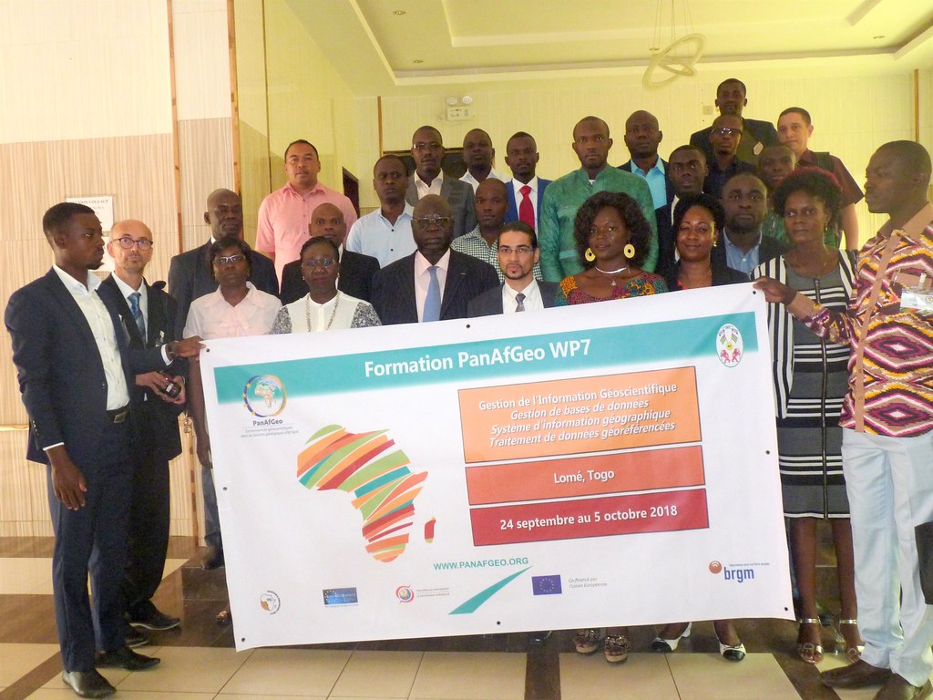
GESTION DE L’INFORMATION GÉOSCIENTIFIQUE
Gestion de bases de données, traitement de données géoréférencées et interface Système d’Information Géographique
LOME, TOGO – 24 SEPTEMBRE-5 OCTOBRE 2018

Lomé, 6 octobre 2018
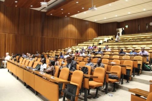
« Gestion de bases de données, traitement de données géoréférencées et interface Système d’Information Géographique » : une session de formation de 10 jours du programme PanAfGeo sur la « Gestion de l’Information géoscientifique » s’est tenue à Lomé, Togo, du 24 septembre au 5 octobre 2018.

20 professionnels des données géoscientifiques de 11 pays africains (Algérie, Bénin, Burkina Faso, Cameroun, Côte d’Ivoire, Madagascar, Niger, République Démocratique du Congo, Sénégal, Togo et Union des Comores) ont participé à cet atelier de formation. Il était organisé conjointement par le Service géologique français (BRGM) et la Direction Générale des Mines et de la Géologie (DGMG) du Ministère des Mines et de l’Energie de la République togolaise. Plus de 110 candidatures ont été reçues de la part des services géologiques et directions des mines et de la géologie à travers l’Afrique. Les candidats sélectionnés pour cette session représentaient plusieurs types d’organisations géoscientifiques et avaient un parcours technique de géologues, géomaticiens, etc.

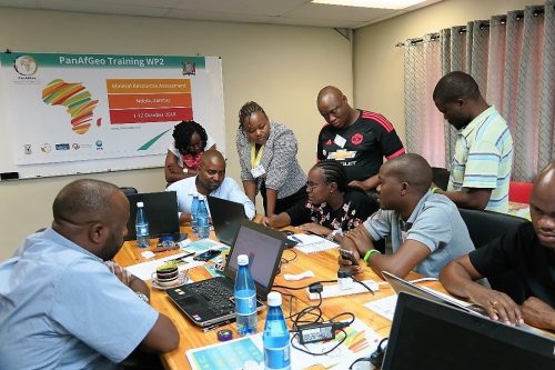
Cet atelier de formation était consacré à la gestion de bases de données, le traitement de données géoréférencées et l’interface SIG.

Les thématiques abordées ont concerné (1) les techniques de gestion de données, de visualisation, de traitement et vérification de ces données et (2) les liens fonctionnels entre les outils présentés de système d’information géographique (SIG) et d’administration de bases de données relationnelles.

La formation s’est déroulée sous forme d’une alternance entre des présentations théoriques (<40%) sur les concepts (SIG et base de données) et une mise en pratique sur ordinateur (>60%). Un ordinateur portable, les logiciels open source (QGIS, PostgreSQL, PostGIS et pgAdmin, etc.), ainsi que les supports (versions papier et numérique) et les jeux de données utilisés pendant la formation ont été fournis aux participants pour appliquer concrètement les concepts. Les exercices proposés et réalisés en autonomie avec encadrement par les formateurs ont permis aux participants de se familiariser et de s’approprier les bonnes pratiques et techniques quant à l’utilisation de ces logiciels. Ainsi, ils mettent en pratique par eux-mêmes l’ensemble des concepts abordés pendant ces deux semaines puis de retour dans leurs organisations respectives.

En fin de seconde semaine de formation, chaque participant a préparé, puis présenté un Plan de Retour au poste de Travail. Il correspond à la contribution identifiée par le stagiaire, grâce à la formation, pour le renforcement des capacités de son organisation dans la gestion de bases de données, traitement de données géoréférencées et interface SIG. Il s’agit là d’un indicateur de la réussite de la mise en oeuvre du programme des formations PanAfGeo. Il était demandé aux participants de concevoir un projet à court terme/une application de leurs nouvelles connaissances et compétences dans l’intérêt de leur organisation de rattachement et à mettre en place dans les 3 à 6 mois après l’atelier.

Les Plans de Retour au poste de Travail présentés couvraient un éventail significatif d’objectifs tels que :
• Mutualiser et réorganiser les données existantes, les structurer et les modéliser pour créer une nouvelle base de données nationale (connaissances géologiques s.l. ; permis et activités de recherche minière) ;
• Mettre en place une base de données statistiques dans une direction régionale pour une classification géologique et minière de trois régions ;
• Intégrer les données de géophysique, géo-risques, inventaire minéral et patrimoine géologique à la banque nationale de données géologiques puis diffusion des informations publiques ;
• Renforcer l’utilisation de QGIS en préparation de documents de mission de géologie et géophysique puis traitement et production des résultats ;
• Corriger et fiabiliser les données géoscientifiques régionales pour alimenter à court terme le système d’informations géologiques et minières national ;
• Former ou sensibiliser les équipes de travail locales aux logiciels QGIS, PostgreSQL et PostGIS ;
• Transférer les nouvelles connaissances aux étudiants du Département des Science de la Terre de l’université.

Le contenu de l’atelier et les supports de formation ont été organisés par Philippe Daniels et Rabha Ellouz du Service géologique français (BRGM). Ils ont été assistés dans l’animation par Koffi Evenyon Kassegne et Nakpane Nissao Konkondji de la Direction des Mines et de la Géologie (DGMG). Les contributions de Marc Urvois, Responsable du module WP7 de PanAfGeo, avec l’appui d’Abdoulaye Ouedraogo, Co-Responsable du WP7, Bureau des Mines et de la Géologie du Burkina (BUMIGEB), ont été essentielles pour la réussite de cet atelier.

Des remerciements particuliers sont adressés à Mr Marcel Damégare Sogle, Directeur, DGMG, qui a facilité avec son équipe la coordination des moyens locaux pour que l’atelier se déroule dans les meilleures conditions possibles.

Les cérémonies d’ouverture et de clôture de l’atelier ont été placées sous le haut patronage de Mr Marc Dèdèriwè Abli-Bidamon, Ministre des Mines et de l’Energie, représenté par Mr Bandifoh Ouro-Akondo, Conseiller Technique du ministre, ainsi que Mr Vincent Vire, Chef de la Coopération entre l’Union européenne et le Togo et Mr Morgan Rohel, Responsable sectoriel Développement durable et Gouvernance au Service de Coopération et d’Action culturelle de l’Ambassade de France au Togo.

Prochaines sessions de formation :

Les objectifs à long terme du Workpackage 7 (WP7) de PanAfGeo « Gestion de l’Information Géoscientifique » sont :
(1) La gestion de la connaissance géologique et la diffusion de l’information publique à travers des noeuds nationaux au sein d’un réseau panafricain ainsi qu’un système d’informations géologiques et minières en appui aux activités développées par un large éventail de de parties prenantes nationales et régionales ;

(2) Améliorer et/ou renforcer les compétences du personnel employé par les services géologiques et/ou les directions des mines africaines dans le domaine de la gestion des données géoscientifiques et des technologies de l’information :
o Gestion de bases de données, traitement de données géoréférencées et interface SIG (WP7-A),
o Infrastructure de données géoréférencées – Modélisation de données – Normes d’interopérabilité – Diffusion de données (WP7-B),
o Modélisation géologique 3D multicouche avec logiciel géoscientifique (WP7-C).

La prochaine session de formation WP7-C se déroulera à Windhoek, Namibie (28 janvier-8 février 2019).

Pictures of the training are available here.

Report of Geoheritage training session WP6-3: Windhoek, Namibia, 29 Oct-03 Nov 2018

Geoheritage

Session WP6-3: Windhoek, Namibia

29 October – 3 November, 2018


Brief description of the course content and visited places

Venue: Premises of the Geological Survey of Namibia (GSN), Windhoek, capital of Namibia

Coordinator of WP6: Enrique Díaz-Martínez, Geological Survey of Spain (IGME).

Co-Coordinators of WP6-3: Kombada Mhopjeni and Helcke Mocke, Geological Survey of Namibia (GSN).

The third session of Work-Package 6 on Geoheritage, a 6-day training programme on geoconservation provided by the PanAfGeo project, was held in Windhoek, Namibia, from 29th October to 3rd November 2018. There were 35 applications received and carefully examined before the course, and 29 of them were approved and selected. The final list of trainees included personnel from the geological surveys of 10 African countries, as well as professionals from two Namibian government organizations: the Namibia National Commission for UNESCO (under the Ministry of Higher Education, Training and Innovation), and the Namibian National Heritage Commission. The training team included staff from the Geological Survey of Namibia (GSN), the Geological Survey of Spain (IGME), the other aforementioned Namibian government organizations, and from a mining company.

The welcoming address at the opening ceremony was given by Anna Nguno, acting in place of the CEO of the GSN, followed by introductory lectures by Enrique Díaz-Martínez, WP6 leader. A comprehensive overview of the geology and geoheritage of Namibia was provided by Alfeus Moses and Jason Indongo, of the GSN.

During the training, lectures and presentations of case studies were given, covering the main concepts and methodologies used in geoheritage studies: inventories, value assessment, legislation, geoconservation, management and public use, including geoparks, geotourism and public outreach. During both the discussions and fieldwork, case studies of geoheritage from African countries were used as examples, giving the opportunity to the participating staff from the Namibia National Commission for UNESCO (NNCU) and the National Heritage Commission (NHC) to showcase their geoheritage.

Field work took place for three days and allowed to observe and discuss in situ some Namibian geological sites of interest for discussion and practical considerations. The type stratigraphic section of the Gurumanas Evaporite Member of the Duruchaus Formation (early Neoproterozoic) was used as an example of a small geosite with very high scientific value, as it is one of the older examples in the world for classical evaporites and their metamorphism. Several small outcrops within the city of Windhoek were used to showcase petrologic and tectonic geosites of lower (regional) relevance. This allowed to assess and compare the different administrative levels of geosite management, both in regard to protection and to public use. Finally, the recently discovered paleontological outcrop near Toronto Farm was used as an example of larger geosite representative of Quaternary geological processes related with climate changes and human occupation. In all three fieldwork days, the methodology for geosite value assessment was applied through team work, in order to understand the process which helps establish the potential use and priorities for management and conservation.

The lectures provided during the training session were:

– Geoheritage training course and PanAfGeo project, aims and scope. EDM

– The potential of geological survey organizations in geoconservation. EDM

– Geology and geoheritage in the trainees´ countries (10 min talks)

– The geology of Namibia. Alfeus Moses and Jason Indongo, GSN

– Geoheritage, geodiversity and geoconservation concepts. EDM

– International, national and local legislation: examples and perspectives. EDM

– Namibia National Commission for UNESCO at a glance. Frieda Kanime, NNCU

– Activities of the National Heritage Council of Namibia. Erica Ndalikokule, NHC

– Moveable geoheritage: geoconservation of fossil, mineral, rock and meteorite collections. LCU

– Methodologies for the identification and inventory of geoheritage. LCU

– Methodology of the Global Geosites project. EDM

– Description of geoheritage sites: record cards, mapping and data base. LCU

– Evaluation of geoheritage sites: value, vulnerability and risk of degradation. EDM

– Geoconservation initiatives in Namibia: inventories, geotourism and public outreach. Gabi Schneider, former GSN CEO, currently at Namibian Uranium Institute

– Geotourism and public outreach. LCU

– The Spanish Inventory of Geoheritage. EDM

– UNESCO Global Geoparks: examples and role of National Committees. LCU

– Geoheritage of Chad and perspectives for the future. Djimadoum Nambatingar, former director of the Geological Survey of Chad, currently Co-Leader of PanAfGeo WP6 and Vice-President of OAGS.

– Proposal for declaring Driedoornvlagte fossil reef as a national heritage site and challenges experienced, Helcke Mocke, National Earth Science Museum of GSN

–  Running the National Earth Science Museum at the Geological Survey of Namibia. Helcke Mocke, National Earth Science Museum of GSN

– Perspectives for UNESCO Global Geoparks in Africa. EDM

– Geoconservation in natural and cultural protected areas. EDM

– Final conclusions and future perspectives. LCU and EDM

During the training, a Whatsapp group of PanAfGeo WP6-3 participants was used to exchange practical information, photos and documents. All trainees were supplied with printed copies of lecture presentations, as well as the corresponding digital files in a USB drive (PanAfGeo wrist band) also including other useful documents and reference material. Attendance to the course was 100%, and certificates were presented to all trainees and trainers at the official closure event on the last day. A dinner party was organized afterwards, with the opportunity to taste the local gastronomy.

After the training, an evaluation form was distributed to all participants and feedback was received in the form of filled questionnaires. All responses were positive, including suggestions and constructive remarks for future sessions.

Many thanks are due to the representatives of the Namibia National Commission for UNESCO and the Namibian National Heritage Commission for their interest in and help with the training, and above all to the personnel of the GSN at Windhoek (particularly Kombada Mhopjeni, Helcke Mocke and Anna Nguno) for their help and support with the logistics and organization of the training.

 List of trainees: Total of 28 trainees from 10 countries, 15 men and 13 women.

Report of Mineral Resources Assessment training session WP2-5: Ndola, Zambia, 1-12 Oct 2018

Mineral Resources Assessment

Training session WP2-5: Ndola, Zambia

1 to 12 October 2018

Sixteen geoscientists from nine Southern and Eastern African countries took part to the fifth training session in Mineral Resources Assessment by WP2. The session was organised by GTK in cooperation with the hosting organisation the School of Mines and Mineral Sciences of the Copperbelt University (CBU).

The training took place in Ndola, the capital of the Copperbelt Province of Zambia. The venue was Michelangelo Lodge in the city center of Ndola.

The welcoming address in the opening was given by the Dean of the School of Mines (CBU), Dr. Kawunga Nyirenda.

The lecturers were Dr Pasi Eilu and Dr Tuomo Karinen from GTK, and four invited lecturers from Zambia, Prof. Imasiku Nyambe from the School of Mines of the University of Zambia (UNZA), Prof. Francis Tembo from the Zambian Institute of Earth Sciences and Resources, Mr Pumulo Mukube (CBU), and Mr Wiscort Banda from the Laureates Mining Ventures (LMW).

Topics covered mineral exploration, resource evaluation and the mining value chain, mineral polices and corporate social responsibility.

All the topics were covered in interactive workshops including exercises. On the Trainee Day, the trainees gave several interesting presentations on, e.g. metallogeny, mining history and current activities in their own countries. The Trainee Day with the exchange of experiences with the others is rewarding and facilitates networking also between the trainees’ home organisations.

Visits to the Zambian Lapidary institute in Ndola and the Mufulira copper mine (Mopani Mines) were part of the program. The mine visit also included exercises in drill-core logging, an essential part of the WP2 training.

Feedback from the participants was overly positive. The feedback will be used to further improve the WP2 training, as well as planning of the possible Phase-2 of the PanAfGeo project after 2019.

All trainees were supplied with printed copies and USB sticks of the lecture material and other material inherent to the topics. Certificates of the participation were given to each trainee at the end of the course.

African Union Ministerial Summit

The PanAfGeo team which is present at the African Union Ministerial Summit happening in Addis Ababa, Ethiopia had a meeting with the Commissioner of Trade and Industry of the African Union, Mr. Albert Muchanga. The commissioner recognized the great success of the PanAfGeo project by emphasizing the aspect of the trainees who are coming from more than 43 African countries!

The PanAfGeo team members who were present during the meeting are,

  • Mr. Frank Dixon Mugyenyi (African Union),
  • Mr. Felix Toteu (President of the Advisory Board of the PanAfGeo),
  • Mr. Jean Claude Guillaneau (Coordinator, BRGM),
  • Mr. Isaac Okorie (OAGS),
  • Ms. Céline Andrien (EGS)

Click here to view and download the pictures.

PanAfGeo as a Success Story

PanAf is just one of the many EU instruments that are supporting the Africa- EU Partnership but it is the only EU programme designed to ‘treat Africa as One’. Through continental and trans-regional initiatives, the PanAf complements EU support at regional and country level.

PanAf is the only EU programme designed to ‘treat Africa as One’

SUCCESS STORY:  MANAGING MINERALS

Africa produces around 60 different minerals and metals, but there is a growing recognition that natural resources need to be better understood for the benefits to be reaped at home, and in a more sustainable manner. Helping to achieve this is PanAfGeo, a project providing human resources capacity building and training to the sector. One example of this is a working partnership between Geological Surveys from Europe and Africa. As a result of this, 50 training sessions are planned for 1,200 geologists from all over Africa.

Field Geological Mapping – Completion of training WP1-N3, Tsaobis, Namibia – 20 Aug – 14 Sep 2018

The PANAFGEO Project continues in Windhoek

Work-Package 1 – WP1: Field Geological Mapping
Session WP1-N3: Tsaobis, Namibia
20 August – 14 September 2018

The International project PanAfGeo targeted at the practical improvement and capacity building for the staff of geological surveys of African states. It has been moving around Africa, to anchor the crucial practical trainings in the field geological mapping in Windhoek, Namibia.

The final awarding of the participants´certificates for trainees and the official closing ceremony will be held at the Geological Survey of Namibia on Friday 14 September, around 14.00 hours. The second training of the “Field Geological Mapping” followed the introductory course in Ethiopia early this year. It is focused on the person to person intense teaching of the petrological, structural, sedimentologic and volcanological methods leading to the construction of geological maps on different scales, of which the 1 : 25 000 was applied to the training. An important role in the mapping process is played by remote sensing and GIS approaches that are forming major part of in-door training.

The program took 25 days, combined with in-door lectures, field excursions, demonstration, practice in instrumental methods and a mapping part. The field part was conducted in small groups of trainees, each of them supervised by one expert from Europe or Namibia. The training was coordinated by the Czech team and launched thanks to the joint effort of the experts from the Czech Geological Survey, the Geological Survey of Slovenia, the Geological Survey of Namibia, and with support by local UNAM specialists. The total number of 25 trainees representing 17 different African countries were trained during this training.

The field part was held in theTsaobis National Park which has been used as the traditional field training area by geologist from the University of Namibia. It was complemented by several excursions organized around the Damara belt and in the wider Karibib area. The Karibib area represents ideally exposed and geologically variegated terrain, famous for numerous mineralogical occurrences and mining history. The theoretical and data processing sessions took place atbthe Geological Survey of Namibia in Windhoek.
The PanAfGeo WP1 training in Namibia will be repeated again next year.

Mid-Term meeting of the PanAfGeo project : Dakar, Senegal, 10-11 May 2018

On the 10-11 of May 2018, the Mid-Term meeting of the PanAfGeo project was held in Dakar, Senegal, jointly organised by the French Geological Survey (BRGM) and the Organisation of African Geological Survey (OAGS).

The meeting gathered a range of professionals and leaders from Africa and Europe. Advisory board members, European Consortium partners, African Co-leaders, Expert chair and Executive Committee members discussed the results and the impact of the PanAfGeo project on the African continent. The meeting also had discussions about the future activities and potential second phase of the project.

The first day of the meeting was started with the official introduction and proceeded with the panel discussion entitled ‘What do PanAfGeo trainings bring to my African Geological Survey?’.

The afternoon session continued with the general assembly of the project partners, that reviewed the results of the first year of the project, gave an overview of the past training sessions and received feedback from each work package leaders.

On May 11th the event started with the management committee, where Advisory Board gave recommendations. The meeting continued with the Stakeholders introduction, plus EuroGeoSurveys and UNESCO’s perspective of ASM training.

The meeting ended with the informal discussion between WP Leaders, Co-Leaders and Deputy Co-Leaders.

Click here to view the pictures of the Mid-Term meeting.

Report of Geohazards training session WP5-2: Dar es Salaam, Tanzania , 11 – 18 March 2018

Work-Package 5 Geohazards

Session WP5-2: Dar es Salaam, Tanzania

11 to 18 March 2018

Brief description of the course content and visited places

Over 70 applications were received and examined before the course and 31 were approved. The final list of trainees included 31 persons from 12 African countries. Noteworthy, 7 specialists from AMGC attended the course as well. The training was performed by 9 trainers from Geological Surveys of European countries and South Africa.

The welcoming address at the opening ceremony was given by Mr Ibrahim Shaddad, Director General of AMGC, followed by an introductory lecture by Dr Jonas Satkunas, WP5 leader. A comprehensive overview of geology and geohazards in Tanzania was provided by Prof. A.H. Mruma, the CEO of the Geological Survey of Tanzania (GST).

During the course, lectures and presentations of case studies were given covering the following geohazards: landslides, geopollution, erosion/desertification, land subsidence, hydrogeohazards (including flooding), seismic and volcanic hazards (programme attached). During the discussions, case studies of geohazards from some African countries were presented as well. A feedback from all participants was received in the form of filled questionnaires. All responses were generally positive, and a number of suggestions and constructive remarks were provided.

A 2 day-field trip permitted to observe and discuss some geohazards and environmental issues in Tanzania. Particularly, recent effects of floodings in Dar es Salaam and landslide phenomena in Lushoto region (Usambara Mountains) were analysed. A special focus was also given to the management of slope processes in case of intensive agriculture practice. A field training on the measurement of slope stability parameters received great interest among the participants.

All trainees were supplied with printed lecture copies and USB units including all lecture presentations and other useful material and software. The attendance of the course was 100 percent and certificates of attendance were presented to all trainees.

A Whatsapp group of PanAfGeo WP5 Geohazard participants was created by the trainees to exchange practical information, photos and documents. A very successful and lively attended African song contest among the participants of the course was organised during the social gathering.


Studying flood consequences and management issues in Dar es Salaam.

Training of measurements of the slope stability in Usambara mountains.


Venue: African Minerals and Geosciences Centre (AMGC), Kunduchi Beach Area, P. O. Box 9573, Dar es Salaam, Tanzania

Coordinator of WP-5 Dr Jonas Satkunas, Lithuanian Geological Survey.

Co-Coordinator Dr Souleymane Diop, Council for Geoscience of Republic of South Africa

Report of Geohazards training session WP5-1: Pretoria, 20 – 26 Nov 2017

Work-Package 5 Geohazards

Session WP5 -1: Pretoria, South Africa

20 to 26 November 2017


Brief description of the course content and visited places

Over 70 applications were received and examined before the course and 34 were approved. However 2 trainees withdraw just before the course and 2 trainees did not arrive (due to problems of visa and health). Final list of trainees was 30 persons from 20 African countries (see attached list).

The training was performed by 9 trainers from European countries and two from Council for Geoscience, South Africa. Field instructors were: Souleymane Diop (Council for Geoscience), Mariette Liefferink (CEO: FEDERATION FOR A SUSTAINABLE ENVIRONMENT), Greg Heath and Lourens Hildebrand (Sibanye Stillwater).

The welcoming addresses at the opening ceremony were given by the CEO of Council for Giosciences Mr Mosa Mabuza, and WP5 leader Dr Jonas Satkunas.

During the course, lectures and presentations of case studies were given covering the following geohazards: landslides, geopollution, erosion/desertification, land subsidence, flooding, seismic and volcanic hazards (programme attached). A comprehensive overview of geohazards in South Africa was provided by Dr Souleymane Diop and Dr Henk Coetzee. During the seminar, case studies of geohazards of Ghana, Nigeria and other countries were discussed.

Feedback from all participants was received in the form of filled questionnaires and all responses were positive, with a number of suggestions and constructive remarks.

During the field exercises in Gauteng and Mpumalanga provinces, the geohazards and environmental problems related to geopollution due to gold mining, karstic sinkholes, acid mine drainage, underground combustion of coal and land subsidence were demonstrated and discussed, with particular attention to management of consequences.

All trainees were supplied with printed lecture materials and USB units with all course presentations and other materials. Attendance of the course was 100 percent and certificates of attendance were presented to all trainees. A social network PanAfGeo WP5 Geohazard (WhatsApp group) was formed by participants to exchange practical information, photos and documents.


Geohazards training course programme

Pretoria, 19-27 November 2017.

Venue, Council for Geoscience, 280 Pretoria Street, Silverton Pretoria 0184, South Africa

Coordinator of WP05 Dr. Jonas Satkunas, Lithuanian Geological Survey

Co-Coordinator from Council for Geoscience of Republic of South Africa – Dr Souleymane Diop

Participants of the PanAFGeo WP N5 Geohazards training course in the Republic of South Africa, Pretoria, November 20-26, 2017. Group photo taken by Jolanta Cyziene

Report of Geoheritage Session WP6-2: Dodoma, Tanzania, 14-19 May 2018

Work-Package 6 – Geoheritage

Session WP6-2: Dodoma, Tanzania

14-19 May 2018

Brief description of the course content and visited places

Venue: Hotel Nashera, Dodoma, capital of Tanzania

Coordinator of WP6: Enrique Díaz-Martínez, Geological Survey of Spain (IGME).

Co-Coordinator of WP6-2: John D. Kalimenze, Geological Survey of Tanzania (GST).

The second session of Work-Package 6 on Geoheritage, a 6-day training programme on geoconservation provided by the PanAfGeo project, was held in Dodoma, Tanzania, from 14th to 19th of May 2018. Over 50 applications were received and carefully examined before the course, and 31 of them were approved and selected. The final list of trainees included personnel from the geological surveys of 11 African countries, as well as 6 professionals from the staff of the Ngorongoro UNESCO Global Geopark (UGG). The training team included a trainer from the Geological Survey of Tanzania (GST), two from the Geological Survey of Spain (IGME), and one from the Ngorongoro Conservation Area Authority (NCAA) and UGG.

The welcoming address at the opening ceremony was given by Maruvuko E. Msechu, acting CEO of the GST, followed by introductory lectures by Enrique Díaz-Martínez, WP6 leader. A comprehensive overview of the geology and geoheritage of Tanzania was provided by John D. Kalimenze, of the GST.

During the training, lectures and presentations of case studies were given, covering the main concepts and methodologies used in geoheritage studies: inventories, value assessment, legislation, geoconservation, management and public use, including geoparks, geotourism and public outreach. During both the discussions and fieldwork, case studies of geoheritage from African countries were used as examples, giving the opportunity to the participating staff from Ngorongoro NCAA and UGG to showcase their geoheritage.

Field work took place during three days and allowed to observe and discuss in situ some Tanzanian geological sites of interest for discussion and practical considerations. The type locality of yoderite, a rare mineral very rarely found in the world, was used as an example of a small geosite with very high scientific value. The methodology for geosite value assessment was applied through team work, to understand the process which helps establish the potential use and priorities for management and conservation. The World Heritage site of Kondoa rock paintings at Kolo was used as an example of cultural heritage of international relevance, but without any geoheritage of international relevance. This allowed to assess the difference between natural and cultural heritage, as well as between the different administrative levels of relevance. Finally, the Lake Bahi was used as an example of large geosite representative of geological processes related with the East African Rift.

The lectures provided during the training session were:

– Geoheritage training course and PanAfGeo project, aims and scope. EDM and JK

– The potential of geological survey organizations in geoconservation. EDM

– Geology and geoheritage in the trainees´ countries (10 min talks)

– Geoheritage, geodiversity and geoconservation concepts. EDM

– Investigation and evaluation of geological heritage. JK

– International, national and local legislation: examples and perspectives. EDM

– Methodology of the Global Geosites project. EDM

– Moveable geoheritage: geoconservation of fossil, mineral, rock and meteorite collections. JVS

– Methodologies for the inventory and identification of geoheritage. JVS

– Description of geoheritage sites: record cards, mapping and data base. JVS

– Evaluation of geoheritage sites: value, vulnerability and risk of degradation. EDM

– The Spanish Inventory of Geoheritage. JVS

– Geotourism and public outreach. JVS and EDM

– UNESCO Global Geoparks: examples and role of National Committees. EDM

– Geology and geoheritage inventory of the Ngorongoro Conservation Area. JK

– Ngorongoro-Lengai: from the proposal to management of a UNESCO Global Geopark. JM

– Perspectives for UNESCO Global Geoparks in Africa. JM and EDM

– Geoconservation in natural and cultural protected areas. EDM

– Final conclusions and future perspectives. JVS and EDM

During the training, a Whatsapp group of PanAfGeo WP6-2 participants was created by the trainees to exchange practical information, photos and documents. All trainees were supplied with printed copies of lecture presentations, as well as the corresponding digital files in a USB drive (PanAfGeo wrist band) also including other useful documents and reference material. Attendance to the course was 100%, and certificates were presented to all trainees and trainers at the official closure event on the last day. A successful and lively party was organized afterwards, with opportunities to learn traditional dances and taste the local gastronomy.

After the training, an evaluation form was distributed to all participants and feedback was received in the form of filled questionnaires. All responses were positive, including suggestions and constructive remarks for future sessions.

Many thanks are due to the Kondoa Kolo WHS personnel (particularly to the Site Manager, Zuberi Mabie) and the NCAA and UGG personnel (particularly Joshua Mwankunda, Manager of the Cultural Heritage Department) for their interest in and help with the training, and above all to the personnel of the GST at Dodoma (particularly John Kalimenze) for their help and support with the logistics and organization of the training.

https://business-hall.khm.gov.ua/ https://cnap.khm.gov.ua/ https://shevchenko.khm.gov.ua/ https://veteran.khm.gov.ua/ https://zonbox.pl/