
GEOSCIENCE INFORMATION MANAGEMENT
Database management, handling of spatial data and GIS interface
ACCRA, GHANA – 20TH NOVEMBER-1ST DECEMBER 2017
Accra, 2nd December 2017
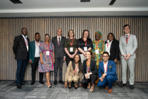
“Database management, handling of spatial data and GIS interface”: a 10-day training session of the PanAfGeo programme on Geoscientific Information Management was held in Accra, Ghana, 20 November-1 December 2017.
17 geodata professionals from 11 African countries (Ethiopia, Ghana, Kenya, Liberia Namibia, Niger, Nigeria, Sierra Leone, Sudan, Tanzania and Zimbabwe) took part in this training. It was jointly organised by the Geological Survey of Denmark and Greenland (GEUS) and the Ghana Geological Survey Authority (GGSA). More than 150 applications have been received from Geological Survey Organisations throughout Africa. The applicants selected for this training represented different organisational units in these surveys and they had a varied background such as geologists, information technology specialists, cartographers, etc.
This training was organised as classroom type sessions including hands-on exercises using sample data sets with different open source software. The main theme of the training was on spatial products, data management and integration. The participants presented their organisation and the spatial data management in their country.
PanAfGeo module WP7-A training focused on strengthening geosciences information management capabilities by presenting different methods, approaches, tools, procedures and requirements for creating spatial products, and doing data management.
The interactive mode of learning through a systematic lecturing approach and practical exercises on computers facilitated a quick learning process in gaining new skills to use open source software such as Quantum GIS, GeoKettle, PostgreSQL/PostGIS and GeoServer.
Over the second week, each trainee had to prepare and present a Return-to-Work Plan as his/her active contribution to the WP7 capacity building process. This is an indicator of the successful implementation of the PanAfGeo training sessions. They were requested to design a short-term application of their newly acquired knowledge through a project of interest for their Geological Survey Organisation and to be possibly implemented over a period of 3 to 6 months after the training.
These Return-to-Work Plans proposed a significant panel of objectives such as:
• Improving and reinforcing the skills of their colleagues in organising trainings;
• Designing a central database gathering all available data;
• Promoting the geoscience data online and populating existing web map portals.
The training curricula and material was organised by Mr. Frands Schjøth and Mr. Bjarni Pjetursson from the Geological Survey of Denmark and Greenland (GEUS). The successful completion of the training session was made possible by the dedicated work of Ms. Keren-Happuch Osekre, Yvonne Marfoa Anokwa and Mr. Emmanuel Adu-Gyamfi from the Ghana Geological Survey Authority (GGSA). The contributions from the WP7 Leader, Mr. Marc Urvois from French Geological survey (BRGM) with support of WP7 co-Leader Mr. Abdoulaye OUEDRAOGO from the Bureau of Mines and Geology of Burkina Faso (BUMIGEB) were also instrumental in this success.
Special thanks are also intended to Mr. Daniel Boamah, Director, GGSA, who facilitated the local coordination to make this training possible in the best conditions.
Coming training sessions:
PanAfGeo Work Package 7 (WP7) “Geoscience Information Management” long-term objectives are:
(1) Geological knowledge management and dissemination of public information through national nodes within a pan-African network along with a geological and mineral information system to support activities developed by a wide panel of national and regional stakeholders;
(2) To improve and/or strengthen the skills and capabilities among the staff employed by the African Geological Survey Organisations in the field of geoscience information management and related information technologies:
o Database management, handling of spatial data and GIS interface (WP7-A)
o Spatial data infrastructure-Data modelling-Interoperability standards-Data dissemination (WP7-B)
o Multilayer 3D geological modelling using dedicated geoscience software (WP7-C)
The next training session (WP7-C) will take place in Dakar, Senegal (15-26 January 2018).