
The PANAFGEO Project continues in Windhoek
Work-Package 1 – WP1: Field Geological Mapping
Session WP1-N3: Tsaobis, Namibia
20 August – 14 September 2018
The International project PanAfGeo targeted at the practical improvement and capacity building for the staff of geological surveys of African states. It has been moving around Africa, to anchor the crucial practical trainings in the field geological mapping in Windhoek, Namibia.
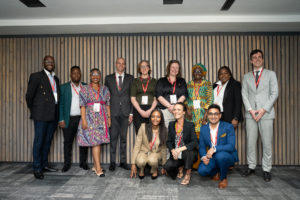
The final awarding of the participants´certificates for trainees and the official closing ceremony will be held at the Geological Survey of Namibia on Friday 14 September, around 14.00 hours. The second training of the “Field Geological Mapping” followed the introductory course in Ethiopia early this year. It is focused on the person to person intense teaching of the petrological, structural, sedimentologic and volcanological methods leading to the construction of geological maps on different scales, of which the 1 : 25 000 was applied to the training. An important role in the mapping process is played by remote sensing and GIS approaches that are forming major part of in-door training.
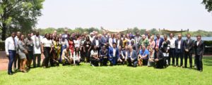
The program took 25 days, combined with in-door lectures, field excursions, demonstration, practice in instrumental methods and a mapping part. The field part was conducted in small groups of trainees, each of them supervised by one expert from Europe or Namibia. The training was coordinated by the Czech team and launched thanks to the joint effort of the experts from the Czech Geological Survey, the Geological Survey of Slovenia, the Geological Survey of Namibia, and with support by local UNAM specialists. The total number of 25 trainees representing 17 different African countries were trained during this training.
The field part was held in theTsaobis National Park which has been used as the traditional field training area by geologist from the University of Namibia. It was complemented by several excursions organized around the Damara belt and in the wider Karibib area. The Karibib area represents ideally exposed and geologically variegated terrain, famous for numerous mineralogical occurrences and mining history. The theoretical and data processing sessions took place atbthe Geological Survey of Namibia in Windhoek.
The PanAfGeo WP1 training in Namibia will be repeated again next year.